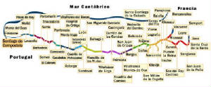
Three routes through France meet north of St Jean Pied-de-Port in the foothills of the Pyrenees, and the
path then crosses into Spain via the valley of Roncesvalles (740 km from Santiago).
The Arles route enters Spain through the Somport pass (840 km from Santiago) to Jaca, and joins the other route at
Puente la Reina. From there, the "Camino Francés" runs through Logroño to Burgos;
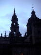
then across the Castillian meseta to León; and finally over two more mountain ranges to reach Galicia and Santiago de Compostela.
After crossing the border from France at Irún in the Basque country, the "Ruta del Norte" or "Camino de
la Costa" runs along the northern coast of Spain, with various branches down to the Camino francés e.g. via the San Adrian
Tunnel to Santo Domingo de la Calzada or from Oviedo to Lugo and then on to Palas do Rey.
The main towns on the northern route are San Sebastián/Donastia, Bilbao, Castro Urdiales, Santander, Ribadesella, Gijón,
Avilés, Luarca, Ribadeo, Mondoñedo and Sobrado dos Monxes, joining the Camino francés at Arzua. Total distance from Irún to
Santiago de Compostela is approximately 825 km.
The most popular of all the routes through Spain is the Camino francés through Roncesvalles.